Aircraft noise · Boston, United States
Boston Logan aircraft noise: flight paths, runways and night flights
About 1,100 planes land and take off at Boston Logan on an average day. Which streets hear them depends on the wind and the runway in use. This is where they fly and how low, measured from a year of recorded flights.
Updated September 29, 2026
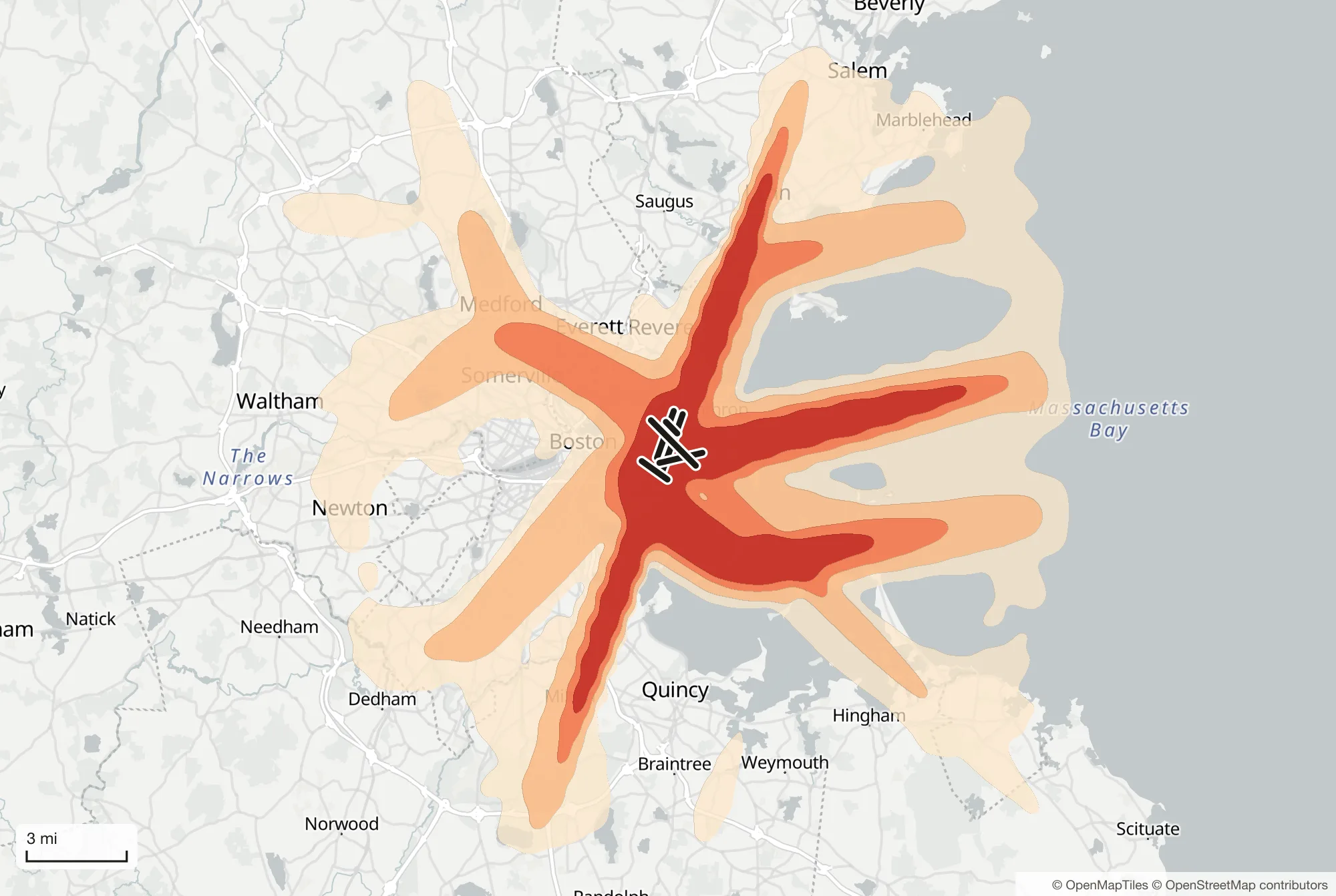
Loud planes a day around Boston Logan
Louder than 65 dB, landings and take-offs, year average
- 1–10
- 10–50
- 50–100
- 100+
Flights a day
1,131
Landings and take-offs on an average day. Busiest: 1,365 on July 8, 2026.
Night flights
174
Between 11:00 pm and 7:00 am on an average night. Busiest night: 276.
Landing towards the north
36%
of days (runway 04). Towards the south on 36%. Both directions on 17%.
Longest quiet at night
80 min
Flights run through the night: on a typical night the longest stretch without a landing or take-off is about 80 minutes, at no fixed time.
From 318 days of recorded flights, September 28, 2025 to September 27, 2026.
Runways and the wind
Boston Logan has six runways: 04L/22R, 04R/22L, 09/27, 14/32, 15L/33R and 15R/33L. Planes land and take off into the wind, and at Boston Logan the wind and the traffic decide which of several runways are in use, often more than one direction at a time. On the main pair of runway directions, planes landed towards the north (runway 04) on 36% of days over the last year and towards the south (runway 22) on 36%. On the other 17%, the direction changed during the day. The other runways carry a good share too: 33 (north-west) 14% of flights, 27 (west) 13%, 09 (east) 12% and 15 (south-east) 10%.
Days towards the south come in spells. In the last year, November, December and March had the most, about half of their days or more. That is why one visit to a house can mislead: a street under one approach can have a quiet week, then weeks of planes.
Where landing planes fly
Landing planes line up with the runway several miles out and descend on a straight, gentle slope, so the same streets hear them at much the same height every time.
Landing towards the north (runway 04R, 59% of these landings), planes line up over Milton, Milton Center, Dorchester and North Quincy and descend to about 1,850 ft 6 miles before the runway and 800 ft at 2.5 miles.
Landing towards the north (runway 04L, 41% of these landings), planes line up over Milton, Milton Village, Dorchester and South Boston and descend to about 1,850 ft 6 miles before the runway and 750 ft at 2.5 miles.
Landing towards the south (runway 22L), planes line up over Salem, Wyoma, Raddin Station and Beachmont and descend to about 1,900 ft 6 miles before the runway and 850 ft at 2.5 miles.
Landing towards the west (runway 27), planes line up over Winthrop and Winthrop Beach and descend to about 1,850 ft 6 miles before the runway and 800 ft at 2.5 miles.
Landing towards the north-west (runway 33L, 97% of these landings), planes line up over Hingham Center, Nantasket Beach, Pemberton and Harbor Islands and descend to about 1,850 ft 6 miles before the runway and 750 ft at 2.5 miles.
Typical height above the airport by distance from the runway end. The band holds the middle half of the flights.
Landing planes pass Winthrop Beach at about 400 ft, Winthrop at about 800 ft, Boston at about 1,500 ft.
Landing towards the north (runway 04), 36% of days
| Before the runway | Runway 04R (59%) | Runway 04L (41%) |
|---|---|---|
| 1.2 miles | Boston 450 ft | South Boston 400 ft |
| 2.5 miles | Boston 800 ft | Boston 750 ft |
| 3.7 miles | North Quincy 1,150 ft | Boston 1,150 ft |
| 5.0 miles | Dorchester 1,500 ft | Dorchester 1,500 ft |
| 6.2 miles | East Milton 1,850 ft | Dorchester 1,850 ft |
| 7.5 miles | Milton Center 2,250 ft | Milton Village 2,200 ft |
| 9.3 miles | Milton 2,750 ft | Milton 2,700 ft |
Landing towards the south (runway 22), 36% of days
| Before the runway | Runway 22L |
|---|---|
| 1.2 miles | Beachmont 500 ft |
| 2.5 miles | Beachmont 850 ft |
| 3.7 miles | Beachmont 1,200 ft |
| 5.0 miles | Raddin Station 1,550 ft |
| 6.2 miles | Lynn 1,900 ft |
| 7.5 miles | Wyoma 2,200 ft |
| 9.3 miles | Salem 2,750 ft |
Landing towards the north-west (runway 33)
| Before the runway | Runway 33L (97%) |
|---|---|
| 1.2 miles | Boston 400 ft |
| 2.5 miles | Harbor Islands 750 ft |
| 3.7 miles | Harbor Islands 1,150 ft |
| 5.0 miles | Pemberton 1,500 ft |
| 6.2 miles | Fort Revere 1,850 ft |
| 7.5 miles | Nantasket Beach 2,150 ft |
| 9.3 miles | Hingham Center 2,700 ft |
Landing towards the west (runway 27)
| Before the runway | Runway 27 |
|---|---|
| 1.2 miles | Winthrop Beach 400 ft |
| 2.5 miles | Winthrop 800 ft |
| 3.7 miles | Winthrop 1,150 ft |
| 5.0 miles | Boston 1,500 ft |
| 6.2 miles | Boston 1,850 ft |
| 7.5 miles | Boston 2,200 ft |
| 9.3 miles | Open ground or water 2,700 ft |
Where landing planes pass at each distance from the runway, and their typical height above the airport, from 10 sample days. Place names © OpenStreetMap contributors.
Large jets at these heights are clearly heard well to either side of the line, not only directly beneath it.
Where takeoffs go
Takeoffs climb much faster than landings descend, and they turn onto set routes soon after leaving the runway, so they spread over a wider area at greater heights.
Taking off towards the north (runway 04), planes climb to about 1,750 ft 1 mile past the end of the runway and 3,600 ft at 5 miles. Most head north-east, passing Revere at about 3,650 ft.
Taking off towards the south (runway 22), planes climb to about 1,550 ft 1 mile past the end of the runway and 3,450 ft at 5 miles. Most head south-east, passing Harbor Islands at about 3,700 ft; about 24% turn south, over North Quincy.
Taking off towards the north-west (runway 33), planes climb to about 1,800 ft 1 mile past the end of the runway and 3,700 ft at 5 miles. Most head north-west, passing Glenwood at about 3,700 ft.
Taking off towards the west (runway 27), planes climb to about 1,650 ft 1 mile past the end of the runway and 3,600 ft at 5 miles. Most head south-west, passing Roxbury at about 3,650 ft.
Taking off towards the east (runway 09), planes climb to about 1,650 ft 1 mile past the end of the runway and 3,350 ft at 5 miles. Most head east.
Taking off towards the south-east (runway 15), planes climb to about 950 ft 1 mile past the end of the runway and 3,250 ft at 5 miles. Most head south-east, passing Harbor Islands at about 3,350 ft.
Taking off towards the north (runway 04), 36% of days
Typical height past the end of the runway: 1,750 ft at 1.2 miles, 2,300 ft at 2.5 miles, 2,900 ft at 3.7 miles, 3,600 ft at 5.0 miles.
| Heading | Share | Passing, 5.0 miles out |
|---|---|---|
| North-east | 90% | Revere 3,650 ft |
Taking off towards the south (runway 22), 36% of days
Typical height past the end of the runway: 1,550 ft at 1.2 miles, 2,100 ft at 2.5 miles, 2,750 ft at 3.7 miles, 3,450 ft at 5.0 miles.
| Heading | Share | Passing, 5.0 miles out |
|---|---|---|
| South-east | 60% | Harbor Islands, Boston 3,700 ft |
| South | 24% | North Quincy, Quincy 2,600 ft |
Taking off towards the north-west (runway 33)
Typical height past the end of the runway: 1,800 ft at 1.2 miles, 2,350 ft at 2.5 miles, 3,000 ft at 3.7 miles, 3,700 ft at 5.0 miles.
| Heading | Share | Passing, 5.0 miles out |
|---|---|---|
| North-west | 95% | Glenwood, Medford 3,700 ft |
Taking off towards the west (runway 27)
Typical height past the end of the runway: 1,650 ft at 1.2 miles, 2,250 ft at 2.5 miles, 2,900 ft at 3.7 miles, 3,600 ft at 5.0 miles.
| Heading | Share | Passing, 5.0 miles out |
|---|---|---|
| South-west | 96% | Roxbury, Boston 3,650 ft |
Taking off towards the east (runway 09)
Typical height past the end of the runway: 1,650 ft at 1.2 miles, 2,200 ft at 2.5 miles, 2,700 ft at 3.7 miles, 3,350 ft at 5.0 miles.
| Heading | Share | Passing, 5.0 miles out |
|---|---|---|
| East | 97% | Boston 3,400 ft |
Taking off towards the south-east (runway 15)
Typical height past the end of the runway: 950 ft at 1.2 miles, 1,750 ft at 2.5 miles, 2,450 ft at 3.7 miles, 3,250 ft at 5.0 miles.
| Heading | Share | Passing, 5.0 miles out |
|---|---|---|
| South-east | 86% | Harbor Islands, Boston 3,350 ft |
Take-offs turn onto different routes, so these are the main groups rather than one line. From 10 sample days. Place names © OpenStreetMap contributors.
Night flights and quiet hours
On an average night over the last year, 174 planes landed or took off between 11:00 pm and 7:00 am, and 276 on the busiest night. Flights run through the night: on a typical night, the longest stretch without a landing or takeoff is about 80 minutes, at no fixed time. Traffic builds from about 6:00 am, and the busiest hour is 6:00 pm–7:00 pm, with about 72 flights.
Night, 11:00 pm–7:00 am. Average of 10 sample days across the year, local time.
Show as a table
| Hour | Flights | Hour | Flights |
|---|---|---|---|
| 12:00 am–1:00 am (night) | 19 | 12:00 pm–1:00 pm | 58 |
| 1:00 am–2:00 am (night) | 8 | 1:00 pm–2:00 pm | 60 |
| 2:00 am–3:00 am (night) | 3 | 2:00 pm–3:00 pm | 66 |
| 3:00 am–4:00 am (night) | 2 | 3:00 pm–4:00 pm | 69 |
| 4:00 am–5:00 am (night) | 4 | 4:00 pm–5:00 pm | 66 |
| 5:00 am–6:00 am (night) | 17 | 5:00 pm–6:00 pm | 67 |
| 6:00 am–7:00 am (night) | 47 | 6:00 pm–7:00 pm | 72 |
| 7:00 am–8:00 am | 61 | 7:00 pm–8:00 pm | 67 |
| 8:00 am–9:00 am | 66 | 8:00 pm–9:00 pm | 58 |
| 9:00 am–10:00 am | 70 | 9:00 pm–10:00 pm | 53 |
| 10:00 am–11:00 am | 65 | 10:00 pm–11:00 pm | 43 |
| 11:00 am–12:00 pm | 61 | 11:00 pm–12:00 am (night) | 38 |
Night rules differ from airport to airport: how curfews, quotas and bans work explains the kinds there are.
Busy days and quiet days
Over the year, Boston Logan averaged about 1,100 landings and takeoffs a day. The quietest month was January, with about 960 a day, and the busiest June, with about 1,200. Saturday is the quietest day of the week and Thursday the busiest. For most homes nearby, though, the runway direction matters more than the number of flights.
Checking a home near Boston Logan
These figures describe the airport as a whole. What one home hears depends on how close it is to the lines above, how often those runways are used and at what time. How to check aircraft noise before buying a house sets out the checks, and is this house under a flight path? shows how to find the lines on a map. To raise a noise problem, how to complain about aircraft noise explains where to start.
Questions
What time do flights stop at Boston Logan?
Flights at Boston Logan run through the night. On a typical night the longest stretch without a landing or takeoff is about 80 minutes, and there are about 174 flights between 11:00 pm and 7:00 am.
Which way do planes land at Boston Logan?
It depends on the wind. On the main pair of runway directions, planes landed towards the north (runway 04) on 36% of days over the last year and towards the south (runway 22) on 36%. On the other 17%, the direction changed during the day. The other runways carry a good share too: 33 (north-west) 14% of flights, 27 (west) 13%, 09 (east) 12% and 15 (south-east) 10%.
How low do planes fly near Boston Logan?
Landing towards the north (runway 04R), planes are about 1,150 ft over North Quincy and about 1,850 ft over East Milton. Landing towards the north (runway 04L), planes are about 1,850 ft over Dorchester. Heights are above the airport, from a sample of days across the year.
How many flights are there at Boston Logan a day?
About 1,100 landings and takeoffs on an average day over the last year, from about 960 a day in January to 1,200 in June. The busiest day had 1,365.
How can I check aircraft noise at an address near Boston Logan?
Replay a real day at Boston Logan on our free flight map and tap the street to see how many loud planes it heard, on a day in each runway direction. A Flight Noise report does the same for a full year of flights at one address.
Sources
Flight figures: Flight Noise, from every landing and take-off recorded by ADS-B receivers (ADSB.lol, ODbL) over the period shown above.
Related guides
- Buying or renting near an airportHow to check aircraft noise before buying a house
- Why planes are over your houseWhy are planes flying over my house today?
- Understanding aircraft noiseHow high do planes fly when landing and taking off?
- Complaints, rules and rightsNight flights: how curfews, quotas and bans work